# Calcula tu ruta
### Instrucciones para Calcular ruta
**1.Ingresa:** En el menú principal ingresa a **"Calcular ruta"**.

**2.Ubica el Origen:** Puedes definir el origen dando clic en el mapa, digitando el nombre del sitio o la dirección.

{% hint style="warning" %}
**Para tener en cuenta:** El sistema va a indicar la dirección o sitio oficial, por favor espera a que esta parezca y luego selecciónala dando un clic.
{% endhint %}
**3.Ubica el Destino:** Puedes definir el destino dando clic en el mapa, digitando el nombre del sitio o la dirección en la caja de texto.

{% hint style="warning" %}
**Para Tener en cuenta:** el sistema le va a indicar la dirección o sitio oficial, por favor espera a que esta parezca, luego selecciónala dando un clic.
{% endhint %}
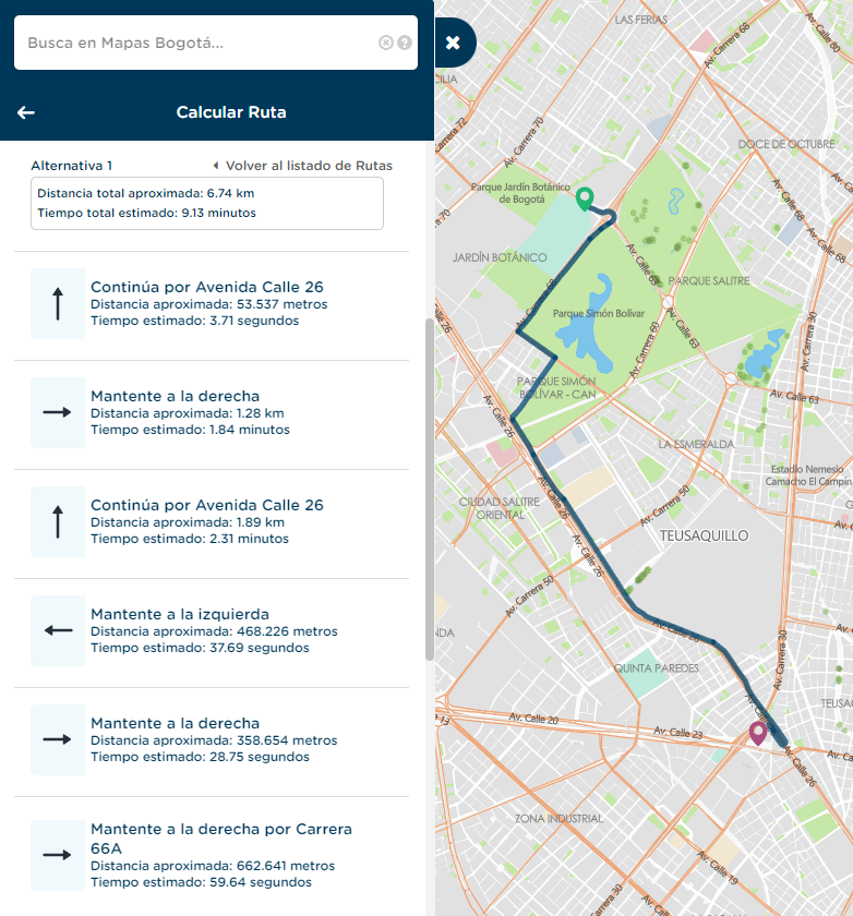
**4.Calcula la ruta:** Puedes calcular la ruta dando clic sobre uno de los medios de transporte disponibles (La Bicicleta es el medio predeterminado) y luego en el botón "calcular" .

{% hint style="info" %}
Mapas Bogotá te ofrece los siguientes medios de transporte: caminando, bicicleta, vehículo particular y transporte público.
{% endhint %}
####
{% tabs %}
{% tab title="Bicicleta" %}
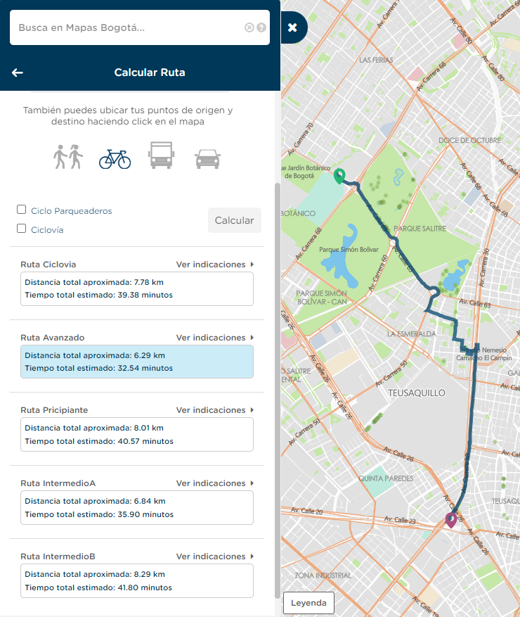
#### Tipos de rutas para tu desplazamiento en bicicleta
{% hint style="success" %}
La ruta para bicicleta te ofrece 5 (cinco) opciones que puedes elegir teniendo en cuenta los siguientes aspectos:
* **Ruta Ciclovía:** utiliza ciclovías y ciclorutas.
* **Ruta Principiante:** utiliza ciclovías, ciclorutas y algunas vías locales.
* **Ruta Intermedio A**: utiliza vías locales de menor complejidad y algunas ciclovías y ciclorutas.
* **Ruta Intermedio B**: utiliza vías locales de mayor complejidad y algunas ciclovías y ciclorutas.
* **Ruta Avanzado**: usa principalmente las vías compartidas con los demás medios de transporte.
{% endhint %}
Si das clic en podrás conocer cada uno de los tramos de la ruta.

{% endtab %}
{% tab title="Caminando" %}
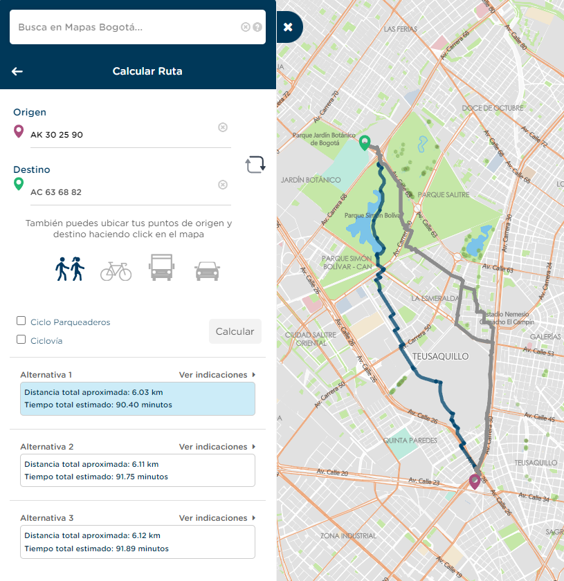
#### Calcula tu ruta te presenta varias alternativas para tu desplazamiento caminando.
Si das clic en podrás conocer cada uno de los tramos de la ruta.
{% endtab %}
{% tab title="Transporte público" %}
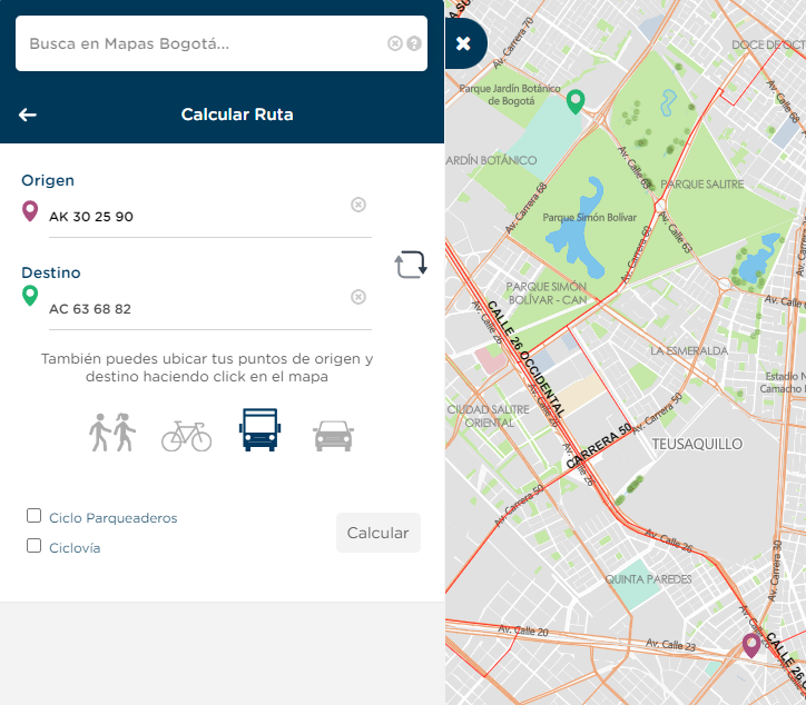
#### Para calcular tu ruta con transporte público selecciona el icono correspondiente.
Al dar clic en el botón de Calcular podrás visualizar las rutas disponibles generadas desde un servicio de Google, acá podrás visualizar la ruta que debes seguir en detalle.
{% endtab %}
{% tab title="Vehículo particular" %}
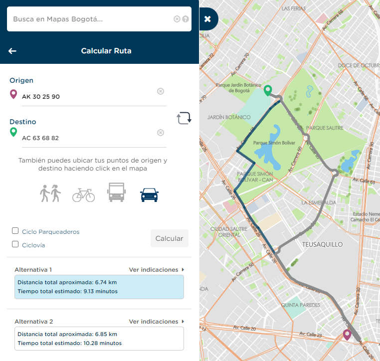
#### Calcula tu ruta te presenta varias alternativas para tu desplazamiento en vehículo particular.
Si das clic en podrás conocer cada uno de los tramos de la ruta.
{% endtab %}
{% endtabs %}
**5. Activa Cicloparqueaderos y Ciclovías:** Cuando ingresas a Calcular ruta, automáticamente se cargan los datos de ciclo parqueaderos y ciclorrutas, puedes hacerlos visibles dando das clic sobre los recuadros en la parte inferior izquierda al lado del botón de calcular.

Ubícate el mapa y da clic sobre el cicloparqueadero o ciclovía de tu preferencia para obtener mayor información.

**6.Intercambiar origen/destino:** Utilizando el botón puedes intercambiar las direcciones de tu ruta, para realizar fácilmente el viaje de regreso.
**7.Salir de calcular ruta:** En la parte superior izquierda utiliza la flecha para salir de la herramienta.

Aparecerá la pregunta ¿Desea borrar la ruta? si respondes **"No"** la ruta quedara visible, podrás agregar más datos y utilizar otras herramientas, Si tu respuesta es afirmativa desaparecerá la información.

---
# Agent Instructions: Querying This Documentation
If you need additional information that is not directly available in this page, you can query the documentation dynamically by asking a question.
Perform an HTTP GET request on the current page URL with the `ask` query parameter:
```
GET https://mapasbogota.gitbook.io/ayuda/calcular-ruta.md?ask=
```
The question should be specific, self-contained, and written in natural language.
The response will contain a direct answer to the question and relevant excerpts and sources from the documentation.
Use this mechanism when the answer is not explicitly present in the current page, you need clarification or additional context, or you want to retrieve related documentation sections.
 (La Bicicleta es el medio predeterminado) y luego en el botón "calcular" .

{% hint style="info" %}
Mapas Bogotá te ofrece los siguientes medios de transporte: caminando, bicicleta, vehículo particular y transporte público.
(La Bicicleta es el medio predeterminado) y luego en el botón "calcular" .

{% hint style="info" %}
Mapas Bogotá te ofrece los siguientes medios de transporte: caminando, bicicleta, vehículo particular y transporte público.  podrás conocer cada uno de los tramos de la ruta.

{% endtab %}
{% tab title="Caminando" %}
#### Calcula tu ruta te presenta varias alternativas para tu desplazamiento caminando.
podrás conocer cada uno de los tramos de la ruta.

{% endtab %}
{% tab title="Caminando" %}
#### Calcula tu ruta te presenta varias alternativas para tu desplazamiento caminando.


 puedes intercambiar las direcciones de tu ruta, para realizar fácilmente el viaje de regreso.
**7.Salir de calcular ruta:** En la parte superior izquierda utiliza la flecha para salir de la herramienta.

Aparecerá la pregunta ¿Desea borrar la ruta? si respondes **"No"** la ruta quedara visible, podrás agregar más datos y utilizar otras herramientas, Si tu respuesta es afirmativa desaparecerá la información.

---
# Agent Instructions: Querying This Documentation
If you need additional information that is not directly available in this page, you can query the documentation dynamically by asking a question.
Perform an HTTP GET request on the current page URL with the `ask` query parameter:
```
GET https://mapasbogota.gitbook.io/ayuda/calcular-ruta.md?ask=
puedes intercambiar las direcciones de tu ruta, para realizar fácilmente el viaje de regreso.
**7.Salir de calcular ruta:** En la parte superior izquierda utiliza la flecha para salir de la herramienta.

Aparecerá la pregunta ¿Desea borrar la ruta? si respondes **"No"** la ruta quedara visible, podrás agregar más datos y utilizar otras herramientas, Si tu respuesta es afirmativa desaparecerá la información.

---
# Agent Instructions: Querying This Documentation
If you need additional information that is not directly available in this page, you can query the documentation dynamically by asking a question.
Perform an HTTP GET request on the current page URL with the `ask` query parameter:
```
GET https://mapasbogota.gitbook.io/ayuda/calcular-ruta.md?ask=